


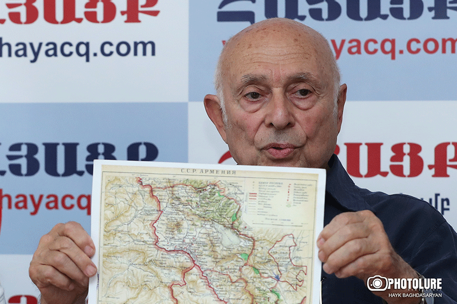
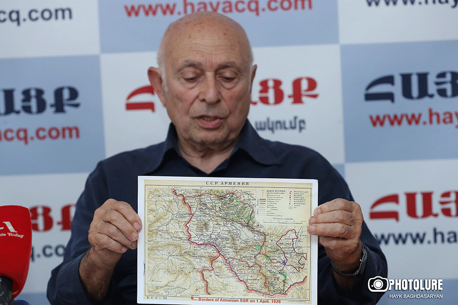
In 1926, the first Soviet encyclopedia was published, where the borders of Armenia were presented․ Nakhichevan and Nagorno-Karabakh were given to Azerbaijan, but official maps show that Armenia and Karabakh border the edge is the Hakari river, and there are no enclaves; they were given to Azerbaijan later: In 1936, Artsvashen region, etc. 1926 According to maps, the territory of Armenia is 31,000 square kilometers, the honorary doctor of the National Academy of Sciences of Armenia, cartographer Ruben Galechyan announced the other day at the “Hayatsk” club and showed the map he mentioned.
According to him, there are already enclaves in the maps published in 1930-1940, but only in the maps. There are no documents; it needs to be known for what reasons they were given to Azerbaijan. There are opinions that Azerbaijanis lived there for 200 years, that’s why it was given. Galechyan counters that it is a lie. “Azerbaijan did not exist 200 years ago, Turks may have lived there, and if we divide it like that, Armenians have lived in Artsakh for 2000 years, so all of Artsakh should be Armenian.” Comparing the positions of Azerbaijani and Armenian enclaves in Armenia is not in our favor. At least two of the Azerbaijani enclaves sit on our highways, one enclave, Artsvashen, does not have such strategic importance.
The “birth” of undocumented enclaves led to the fact that the territory of Armenia increased from 31 thousand square kilometers to 29,800 square kilometers. It is this number that the Prime Minister of Armenia mentions. At the same time, Azerbaijan has seized part of these 29,800 and is not talking about withdrawing. Meanwhile, “Article 2 of the Constitution of Azerbaijan states that current Azerbaijan is the heir of 1918-20 Musafat Azerbaijan and does not recognize Soviet Azerbaijan. Historical Azerbaijan did not have an enclave in Armenia; enclaves appeared in 1936. Their Constitution does not give the right to talk about enclaves. They do not recognize Soviet Azerbaijan, so why do they keep the lands? At one time, some pasture lands from Armenia were handed over to Azerbaijan to create Red Kurdistan, but the plan was canceled, and the lands were not returned; why? If Aliyev wants his villages, we should also want our territories.”
Read also


Russia always prefers Muslims; it has more interest there. Let us be guided by the headquarters maps of 1926. Ruben Galechyan reminds us that the first republic of Armenia did not carry out cartography with its neighbors; the problems with its neighbors were complicated; there was a war, there was no time and opportunity, there were maps of tsarist Russia, in Soviet Armenia, the General Staff of the Armed Forces of the USSR seriously engaged in cartography in 1921-1923, were detailed and secret maps – they had yet to be seen in Armenia.
These are the maps that Russian President Vladimir Putin was talking about when he said that if there is border delimitation between Armenia and Azerbaijan; Russia will have to participate because only Russia has detailed maps. “Interestingly, Putin said that they will publish the maps only at the negotiating table; that is, Armenia and Azerbaijan will not know until the last second what they are negotiating about,” Ruben Galechyan said.
Nelly GRIGORYAN


