


Recently, officials of various calibers have been discussing how the roads passing through Syunik allegedly pass through the territory of Azerbaijan. They refer to Soviet maps. In a conversation with Aravot Daily, the head of the Cartography Department of the USSR Institute of National Economy, the director of Nahapet Publishing House, photographer, and publisher of rare books and albums, Sen Hovhannisyan claims the opposite.
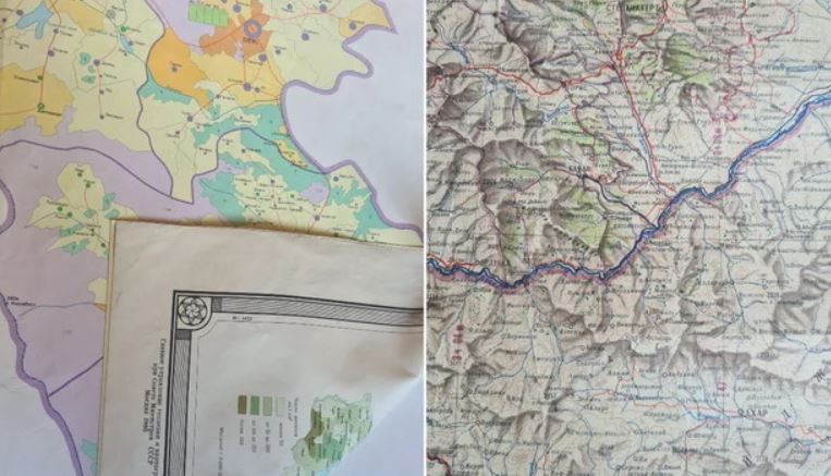
According to him, the allegedly disputed roads are in the territory of Armenia. The expert refers to maps published during the Soviet years, one of which, for example, is a military map of 1953 with a secret stamp. “There has been a lot of talk lately about the Yerevan-Kapan road and whether it will be or has already been handed over to Azerbaijan. There are different opinions as to who owns the road. According to historical maps, these are Armenian territories. But for some reason, some people are skeptical. I have often traveled to Kapan that way and saw the road construction being done. I am surprised that our relevant bodies do not mention that those roads are in the territory of Armenia,” Sen Hovhannisyan told Aravot.
“During the Soviet Union, the Yerevan-Kapan road did not work because there was an uninterrupted railway from Kapan to Yerevan, as well as a Kapan-Yerevan flight several times a day, which lasted 35-40 minutes. Later, when the construction of Tatev HPS began, we paid attention to the new road from Kapan to Vorotan in order to transport the relevant equipment. Road construction works were carried out by Armenia. After the Artsakh war, as a result of the blockade of the railway, that road became even more important. Armenian construction workers did everything to make the road busier, that’s why it was expanded at the expense of our territories,” he said, emphasizing once again that the road is in Armenia.
Read also


“I also witnessed the construction of the Meghri-Kajaran road when the first secretary of the Central Committee, Karen Demirchyan, often came to monitor the road construction. I was in Vorotan once near the Tatev HPS when he came again with a procession. Several people asked why he did not want to open a road to Kapan via Tatev. Karen Serobich looked at the questioner in surprise and said, ‘Who are we going to leave our territories to? After all, Shurnukh is a small settlement from Vorotan to Kapan, and there is no other settlement.’”
Sen Hovhannisyan noted that he once published the map of the population of Armenia in the Minsk Cartographic Factory. He provided some details. “In 1986, I worked at the Institute of National Economy. I was the head of the cartography department. Karen Demirchyan instructed us to compile the map of the population of Armenia. This work was led by PhD of the Institute of National Economy, Professor Grigor Avagyan. Making a map during the Soviet years was a hard and tedious job. Besides, no map was printed in Armenia. The maps had to be printed in Tbilisi (Georgia), Novosibirsk, and Minsk; only they had cartographic factories. This is a large-scale map measuring 93-115 cm created for official purposes. I coordinated the printing of that map. A large group worked on the map with all the ministers finally putting their stamps on the map and signing it to make sure it was accurate. Once there was an interesting case when I took the initial version of the map to Victor Hambardzumyan.
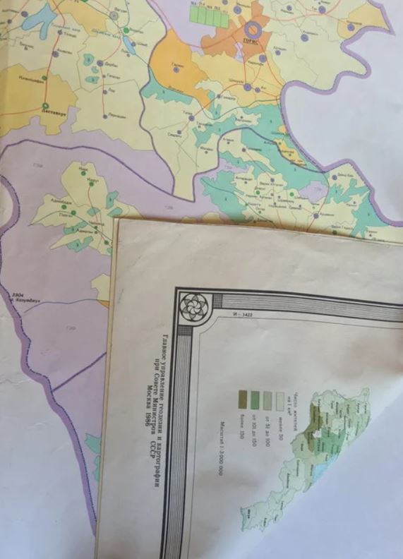
He looked and said that the social migration is shown on the map. It is obvious how many people leave Armenia for work and return, but it is not mentioned how many people do not return. He said that it should be reflected in the map as well. I made the corrections on the map with ink. Victor Hamazaspovich said that it would be good to work with a pencil so that there would be no problem when making corrections, but Moscow demanded that we work with ink. When the map was ready for publication, I went on a business trip to the Minsk Cartographic Factory several times. After a detailed inspection, the map was taken to Moscow, where it was inspected and stamped, after which it was published in Minsk.
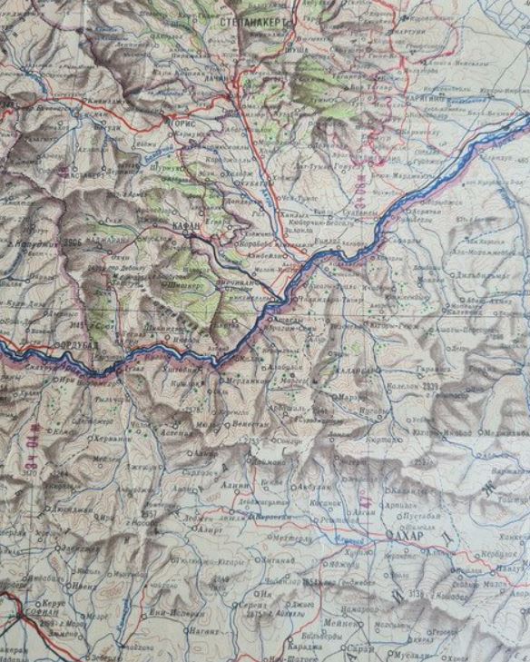
Now, with that map, the Kapan-Goris road passes completely through the territory of Armenia. It was the strictest and most accurate map made by the state. According to that map, the road from Kapan to Vorotan does not pass through the territory of Azerbaijan. The same applies to the road from Chakaten to Kapan. By the way, the map was edited by well-known Russian specialists Kosyakov, Svirskaya, and others. So, no road passes through the territory of Azerbaijan,” Hovhannisyan stated.
Sen Hovhannisyan said he is ready to show the specialists the unique original maps he has.
Gohar Hakobyan


